

Torrential Rains: Understanding the Growing Threat
Cities and Communities Face New Challenges As Intense Rainfall Events Increase
Torrential rains are becoming more intense and more frequent, and they are starting to affect places that once felt safe from severe flooding. Streets turn into rivers in minutes. Homes, transport, and local services struggle to cope. As weather patterns shift, these heavy downpours are no longer rare events. They are a growing risk that demands attention.
Across the world, changing climate conditions are adding more moisture to the air. As a result, storms release larger volumes of water over shorter periods. This leads to flash floods, landslides, and damage that can take years to repair. Cities are especially vulnerable. Many were not designed to handle such sudden and extreme rainfall.
At the same time, the impact goes beyond physical damage. Communities face rising insurance costs, disrupted daily life, and long-term economic strain. For many, the uncertainty is the hardest part. What was once considered a once-in-a-decade storm can now happen far more often.
Understanding why this is happening is key. It helps people, planners, and governments prepare for what comes next. With better awareness, there is also a chance to reduce risk and build stronger, more resilient systems for the future.
What You’ll Discover
Torrential Rains: Why Extreme Downpours Are Increasing Worldwide
What Causes Sudden and Severe Rainfall Events?
Torrential Rains and Climate Change: What’s the Connection?
The Impact of Heavy Rain on Cities, Homes, and Infrastructure
How to Prepare for and Reduce the Risks of Flooding
Conclusion: Why Torrential Rains Demand Our Attention Now
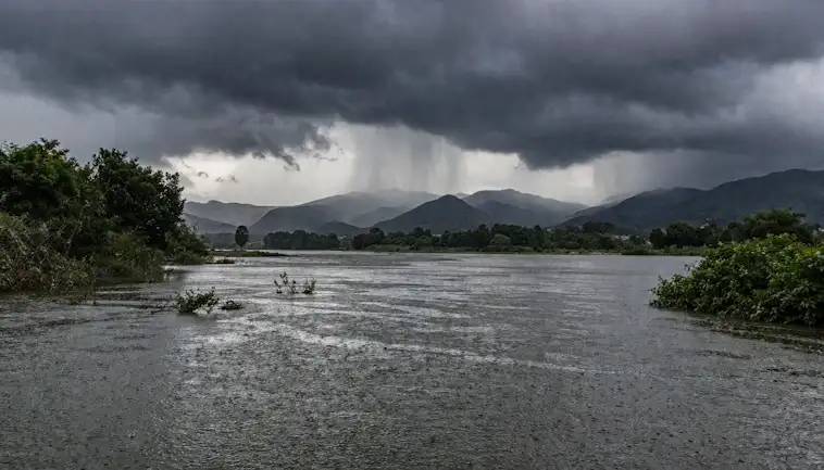
Torrential Rains: Why Extreme Downpours Are Increasing Worldwide
Heavy rain used to feel like a passing event. Now, it often feels relentless. Streets flood faster. Storm drains struggle to cope. And in many places, what once counted as “extreme” is becoming more common.
So, what’s really going on?
In simple terms, the planet is holding more moisture than before. As temperatures rise, the air can carry more water vapor. Then, when conditions are right, that moisture falls all at once. The result is short bursts of very intense rain instead of steady, lighter showers.
At the same time, cities are expanding. More concrete and less green space mean water has nowhere to go. This makes flooding worse, even during storms that might not have caused problems in the past.
But there’s more to the story.
Why Warmer Air Means Heavier Rain
As the atmosphere heats up, it acts like a bigger sponge. It absorbs and stores more moisture. Then, when storms develop, they release that moisture quickly. This leads to heavier downpours in a shorter time.
In fact, studies show that for every degree the temperature rises, the air can hold about 7% more water. That may not sound like much. However, it adds up fast during large storm systems.
The Role of Urban Growth and Changing Weather Patterns
Cities play a key role too. Roads, rooftops, and pavements stop water from soaking into the ground. Instead, rainwater runs off quickly, overwhelming drainage systems.
Meanwhile, weather patterns are shifting. Storms are moving more slowly in some regions. As a result, rain stays over one area longer. This increases the risk of flash floods and damage.
Looking ahead, this trend is likely to continue. Therefore, planning and adaptation will become more important than ever. Better drainage, smarter city design, and early warning systems can all help reduce the impact.
In the end, torrential rains are no longer rare. It’s part of a changing climate. And understanding why it’s happening is the first step toward staying prepared.
What Causes Sudden and Severe Rainfall Events?
Sudden and severe rainfall can feel like it comes out of nowhere. One moment the sky is calm. Then suddenly, heavy rain pours down. So, what is really going on behind the scenes?
In simple terms, these intense downpours happen when the atmosphere holds a lot of moisture and releases it very quickly. However, several key factors often work together to create these extreme weather events. Let’s break it down in a clear and practical way.
The Main Drivers Behind Intense Rainfall
First of all, warm air plays a big role. Warm air can hold more moisture than cold air. As temperatures rise, the air stores more water vapor. Eventually, that moisture needs to go somewhere. When it condenses, it can fall as heavy rain in a short time.
Next, high humidity adds to the problem. When the air is already full of moisture, even a small trigger—like a change in pressure—can lead to a sudden downpour.
In addition, storm systems such as thunderstorms or low-pressure areas can rapidly lift moist air upwards. As the air rises, it cools. Then, the moisture turns into rain clouds and releases heavy rainfall.
Another important factor is urban development. Cities often have more concrete and less natural drainage. As a result, water builds up quickly, making rainfall feel even more intense and disruptive.
Finally, climate change is shaping the bigger picture. Warmer global temperatures are increasing moisture in the atmosphere. This means that when it rains, it is more likely to be heavier and more sudden.
Why These Events Are Becoming More Common
Now, here’s the key shift. These events are not just random anymore. They are happening more often.
As global temperatures continue to rise, the atmosphere is changing. More heat means more moisture. And more moisture means a higher chance of intense rainfall.
At the same time, weather patterns are becoming less predictable. This can lead to storms that develop faster and release rain more aggressively than in the past.
So, while sudden rainfall has always existed, its frequency and intensity are clearly increasing. Looking ahead, understanding these causes can help us better prepare and adapt.
To give you a clearer picture, here is a simple visual showing the main factors that contribute to severe rainfall:
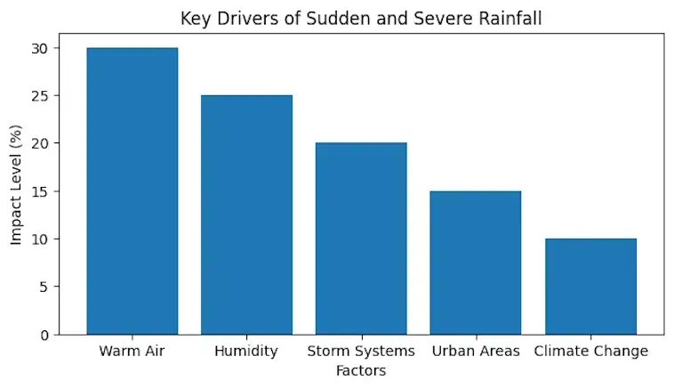
This chart highlights how different elements combine to create these powerful weather events.
Torrential Rains and Climate Change: What’s the Connection?
Torrential rains are becoming more common. And they are hitting harder than before. You may have noticed sudden downpours, flooded streets, or storms that seem to last longer. So, what’s going on?
In simple terms, climate change is warming the planet. As a result, the air can hold more moisture. This means when it rains, it often pours. In other words, torrential rains are not just random events anymore. They are part of a bigger shift in our climate.
At the same time, rising temperatures are changing weather patterns. Storms are slowing down. This causes rain to fall over the same area for longer periods. Consequently, the risk of flooding increases.
How Climate Change Fuels Torrential Rains
To understand the link, it helps to look at how the atmosphere works. Warm air holds more water. Then, when conditions are right, that water is released quickly. This leads to intense rainfall.
Key Factors Driving Heavier Downpours
- Warmer air increases moisture levels in the atmosphere
- Slower-moving storms dump more rain in one place
- Rising sea temperatures add extra energy to weather systems
- Changing wind patterns can trap storms over cities
- Urban areas with less green space struggle to absorb excess water
Because of these factors, torrential rains are expected to become even more frequent in the future. Therefore, cities and communities need to prepare now.
Looking ahead, better drainage systems, smarter urban planning, and early warning systems will play a big role. At the same time, reducing emissions can help slow down these changes.
In short, torrential rains are closely tied to climate change. And understanding this connection is the first step toward staying safe and resilient.
The Impact of Heavy Rain on Cities, Homes, and Infrastructure
Heavy rain is no longer just a seasonal inconvenience. Instead, it is becoming a serious challenge for cities around the world. As weather patterns shift, rainfall is often more intense and less predictable. Because of this, urban areas, homes, and public systems are under growing pressure.
At first, heavy rain may seem harmless. However, when drainage systems are overwhelmed, problems quickly build. Streets flood. Transport slows down. And in many cases, homes and businesses suffer costly damage. So, understanding these impacts is key to preparing for the future.
How Heavy Rain Disrupts Daily Life
When rainfall exceeds what a city can handle, daily routines are often the first to break down. Roads become unsafe. Public transport faces delays. In some areas, people cannot even leave their homes.
Moreover, water can enter buildings through weak points. Basements flood first, but ground floors are also at risk. Over time, this leads to structural damage and rising repair costs. For homeowners, this can be both stressful and expensive.
The Hidden Strain on Infrastructure
Beyond what we see, heavy rain puts silent pressure on infrastructure. Drainage systems can clog or fail. As a result, water backs up into streets and properties. In addition, power systems are vulnerable. Flooded substations can cause outages that affect thousands.
Bridges and roads also wear down faster under constant water exposure. Over time, this weakens key structures. Consequently, cities must spend more on repairs and upgrades. Without action, the gap between demand and capacity will continue to grow.
Supporting Data: Impact of Heavy Rain
To make this clearer, here is a simple visual breakdown of how heavy rain affects different parts of urban life:
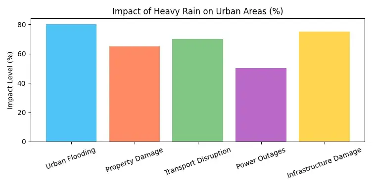
This chart highlights one key point. Urban flooding and infrastructure damage are among the most severe impacts. Therefore, future planning must focus on stronger drainage systems and more resilient design.
Looking Ahead
So, what comes next? Cities are starting to adapt. Green spaces, better drainage, and smart planning are all part of the solution. At the same time, homeowners are becoming more aware of flood risks.
In the future, resilience will matter more than ever. By acting early, both cities and individuals can reduce damage and protect what matters most.
How to Prepare for and Reduce the Risks of Flooding
Flooding is becoming more common. And in many places, it is getting worse. One of the main causes is torrential rains that fall faster than the ground or drainage systems can handle. As a result, homes, roads, and communities can quickly become overwhelmed.
The good news is that there are practical steps you can take. With the right preparation, you can reduce the risks and protect what matters most. In this section, we’ll walk through simple, effective ways to get ready before heavy rain hits. We’ll also look at how small changes today can make a big difference tomorrow.
Understand Your Flood Risk First
Before you take action, it helps to know your level of risk. Not all areas are affected in the same way. Some homes sit on floodplains, while others may face issues due to poor drainage or nearby rivers.
Start by checking local flood maps. Then, look at your surroundings. For example, do you live near a body of water? Does your street collect water during storms? These signs can give you early clues.
Simple Steps to Lower Your Risk
Once you understand your risk, you can act with purpose. Here are a few easy ways to stay ahead of torrential rains:
- Keep gutters and drains clear. This helps water flow away from your home.
- Seal cracks in walls and foundations. Even small gaps can let water in.
- Move valuables to higher levels. This reduces damage if flooding occurs.
- Install barriers or sandbags if you are in a high-risk area.
- Stay informed with weather alerts so you can act quickly.
In addition, consider long-term improvements. For instance, better landscaping can direct water away from your property. Over time, these changes add up and offer stronger protection.
By taking these steps, you’re not just reacting to torrential rains. Instead, you’re planning ahead. And that can make all the difference when the weather turns.
Conclusion: Why Torrential Rains Demand Our Attention Now
Torrential rains are no longer rare events. They are becoming more frequent, more intense, and harder to predict. As a result, communities around the world are facing greater risks, from flash floods to long-term damage to homes, roads, and ecosystems.
At the same time, understanding torrential rains gives us a clear advantage. With better planning, smarter infrastructure, and stronger awareness, it is possible to reduce the impact. Governments, cities, and individuals all have a role to play. Small changes, such as improved drainage or early warning systems, can make a big difference.
Looking ahead, the challenge will only grow. Climate patterns are shifting, and extreme weather is becoming the new normal. However, this also creates an opportunity to adapt and build resilience. By staying informed and prepared, we can face torrential rains with greater confidence.
In the end, torrential rains are not just a weather event. They are a signal. They remind us to act, to prepare, and to rethink how we live alongside nature. The sooner we respond, the better equipped we will be for what comes next.