

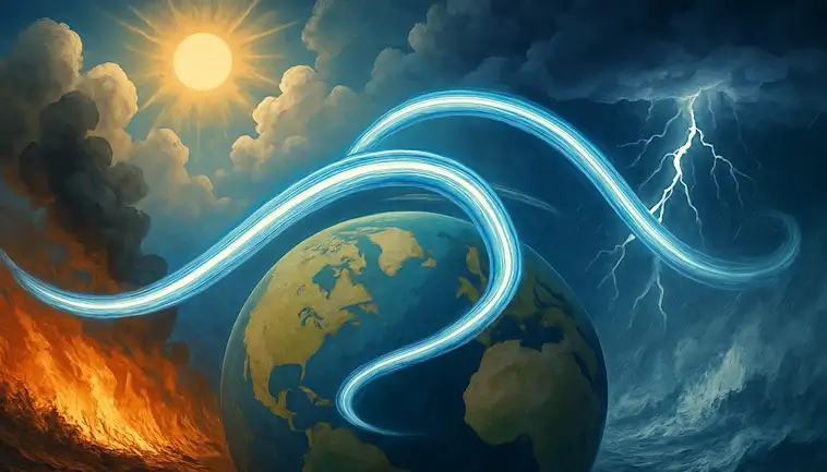
Jet Stream Shifts Are Fueling Wild Weather Swings
Jet Stream Shifts Are Fueling Wild Weather Swings
Weather patterns are behaving in ways that feel increasingly unfamiliar. One week it’s record heat, the next brings flooding rains or unexpected cold snaps. At the center of this growing unpredictability is the jet stream, a powerful air current high above the Earth that acts like a steering wheel for storms and temperatures.
Recent shifts in the jet stream are drawing attention from scientists and forecasters alike. These changes are being linked to more frequent and intense extremes, from heatwaves in Europe to deep freezes in North America. And as the climate warms, the behavior of the jet stream may only grow more erratic.
Understanding what’s driving these changes is key to making sense of today’s weather—and what tomorrow might bring.
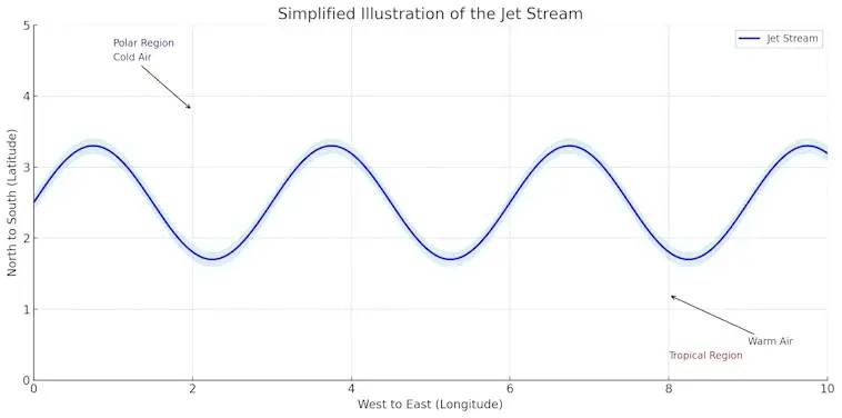
What Is the Jet Stream and Why It Matters
If you’ve ever wondered why the weather can change so quickly—or why storms sometimes seem to follow the same path—it often comes down to one powerful force: the jet stream.
The jet stream is a fast-moving ribbon of air that flows high in the atmosphere, typically around 30,000 to 40,000 feet above the ground. These winds blow from west to east and can reach speeds of over 200 miles per hour. They’re formed by the temperature difference between the cold polar air and the warmer tropical air, and they act almost like a steering wheel for weather systems around the globe.
How the Jet Stream Shapes Our Weather
The jet stream plays a huge role in how weather behaves. It guides storms, moves cold and warm air masses, and even influences how long certain weather patterns stick around. When the jet stream is stable, we tend to get more predictable weather. But when it becomes wavy or sluggish, it can trap systems in place—leading to things like heatwaves, deep freezes, or prolonged rainfall.
For example, a “stuck” jet stream might cause a heat dome over one region, while another area nearby sees nothing but cool, rainy days. So, when meteorologists talk about an unusual weather event, chances are the jet stream has something to do with it.
Why the Jet Stream Is Changing—and Why It Matters More Than Ever
In recent years, scientists have noticed that the jet stream is behaving differently. Some experts believe that climate change—particularly the rapid warming of the Arctic—is weakening the jet stream’s flow. This can make it more meandering and less stable.
Why does that matter to you? Because a weaker jet stream can lead to more extreme weather. Think: flash floods, record-breaking heat, and long-lasting storms. These shifts don’t just affect day-to-day forecasts—they can impact agriculture, energy use, travel, and even the economy.
Understanding how the jet stream works isn’t just for weather geeks. It’s something that affects every one of us, whether we’re planning a weekend trip, running a business, or just trying to stay safe during the next big storm.
How the Jet Stream Influences Global Weather
The jet stream might seem like a distant force high above the Earth, but it has a direct impact on the weather we experience every day—no matter where we live. From the heatwaves in Europe to heavy rains in Asia, the jet stream helps shape global climate patterns.
This powerful, high-altitude wind current acts like a conveyor belt for weather systems. It directs storms, moves cold and warm air masses across continents, and determines how long certain weather conditions last. In short, when the jet stream shifts, the weather shifts with it.
Why Storms Follow the Jet Stream
Have you ever noticed that storms often travel in a consistent direction? That’s thanks to the jet stream. It helps steer storm systems across oceans and land, guiding them from west to east in most parts of the world.
When the jet stream dips, it can pull cold Arctic air far south, causing sudden cold snaps. When it bulges north, it can drag warm, humid air into regions that are usually cooler—sometimes triggering heavy rain, thunderstorms, or even heatwaves.
This steering effect is why meteorologists watch the jet stream closely. It’s one of the best tools we have for predicting major weather events days—or even weeks—in advance.

The Jet Stream’s Global Reach
The jet stream doesn’t just affect local weather. It connects the dots between continents. For example, when the jet stream weakens or stalls, it can cause long-lasting weather patterns. That means one region might suffer a drought while another faces flooding.
El Niño and La Niña events in the Pacific Ocean also interact with the jet stream. These ocean temperature changes shift the jet stream’s path, altering rainfall and temperatures around the world. In some cases, they can even influence hurricane activity and wildfire risks.
Understanding how the jet stream influences global weather is essential in today’s changing climate. As our planet warms, scientists believe the jet stream is becoming more erratic—which could lead to more extreme and unpredictable weather.
So, the next time you check the forecast, remember: the jet stream may be out of sight, but it’s never out of play.
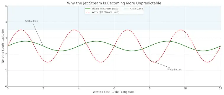
Why the Jet Stream Is Becoming More Unpredictable
In recent years, scientists and meteorologists have noticed a troubling trend: the jet stream is becoming more erratic. Once relatively stable and reliable, this high-altitude wind current is now shifting in unusual ways. The result? More extreme weather, less predictable seasons, and longer-lasting storms.
But what’s behind this change? And why does it matter so much for people around the world?
The Link Between Arctic Warming and Jet Stream Behavior
One of the main drivers behind the jet stream’s increasing unpredictability is the rapid warming of the Arctic. Normally, the jet stream forms because of the strong temperature contrast between cold polar air and warm tropical air. But as the Arctic warms at twice the rate of the rest of the planet, that contrast is weakening.
This weaker contrast means the jet stream slows down and becomes wavier. Instead of flowing in a tight, smooth path from west to east, it starts to dip and rise more dramatically. These larger waves can trap weather patterns in place—causing heatwaves, cold snaps, and flooding to linger far longer than usual.
When Weather Gets Stuck, People Pay the Price
A sluggish jet stream can have serious consequences. In summer, it can lock in heatwaves that fuel wildfires and strain power grids. In winter, it can trap cold Arctic air over cities that aren’t used to freezing temperatures.
In 2021, for example, a stalled jet stream contributed to record-breaking heat in the Pacific Northwest. In 2022, it played a role in devastating floods in Pakistan. These aren’t isolated events—they’re part of a larger pattern of jet stream instability.
As climate change continues to accelerate, scientists expect these unpredictable jet stream shifts to become more common. That means we may need to rethink how we prepare for weather—from how we build our cities to how we grow our food.
The bottom line? The jet stream may be invisible, but its effects are anything but. Understanding how and why it’s changing is key to staying ahead of an increasingly chaotic climate.
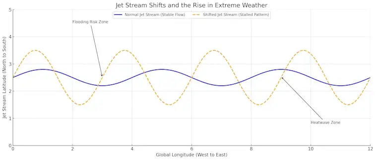
Jet Stream Shifts and the Rise in Extreme Weather
Across the globe, extreme weather events are becoming more frequent, more intense, and harder to predict. From scorching heatwaves to record-breaking floods, the climate is changing—and one of the key forces behind this shift is the jet stream.
The jet stream acts like a giant river of wind high above the Earth, guiding storms, cold fronts, and heatwaves across continents. But as our planet warms, this once-stable system is beginning to behave unpredictably. And that’s fueling some of the most dramatic weather we’re seeing today.
Stalled Jet Streams Are Supercharging Storms
When the jet stream slows down or becomes “stuck” in place, weather patterns can linger for days or even weeks. This can turn a typical rainstorm into a flooding disaster or extend a heatwave into a life-threatening event.
Think of the jet stream as a conveyor belt. When it moves smoothly, weather systems come and go. But when that belt jams or wiggles erratically, it causes traffic—and that “traffic jam” can lead to devastating results on the ground.
In 2023, parts of Europe experienced severe floods after the jet stream parked a storm system over the region for days. The same year, wildfires raged across Canada during a prolonged dry spell linked to a sluggish jet stream.
Climate Change Is Twisting the Jet Stream’s Path
What’s causing these jet stream shifts? A big factor is climate change—especially the rapid warming of the Arctic. As the temperature difference between the poles and the equator decreases, the jet stream loses strength. It begins to meander more, creating deep dips and loops that trap weather in place.
This means extreme heat can bake one area while nearby regions are drenched by unrelenting rain. The result? More weather extremes, more often—and in places that aren’t used to dealing with them.
Understanding how jet stream shifts contribute to extreme weather helps explain why forecasts can feel so unpredictable. But it also gives us a valuable tool. By tracking these changes, scientists and forecasters can give earlier warnings, helping communities prepare and adapt.
The bottom line? The jet stream isn’t just a distant wind in the sky. It’s a global weather engine—and as it changes, so does life on the ground.
Can We Predict Future Jet Stream Changes?
The jet stream plays a crucial role in shaping the weather we experience every day. But with climate change making it more unpredictable, a big question is now on the table: can we accurately forecast how the jet stream will behave in the future?
Scientists are working hard to answer that. Thanks to advances in climate modeling, satellite data, and AI, we’re getting better at spotting patterns. Still, the jet stream remains one of the most complex and dynamic parts of Earth’s atmosphere.
Climate Models Are Improving—But Still Limited
Climate models use powerful computers to simulate how the atmosphere responds to changes in temperature, sea ice, ocean currents, and greenhouse gases. These models have grown more detailed in recent years, allowing researchers to simulate how the jet stream may shift in the coming decades.
Many of these models predict that as the Arctic continues to warm faster than the rest of the planet, the jet stream will become slower and more wavy. This could lead to more weather extremes—especially in mid-latitude regions like North America and Europe.
However, forecasting the jet stream in the short term (like days or weeks ahead) is still tricky. Sudden events like volcanic eruptions or unexpected ocean changes can disrupt even the best models.
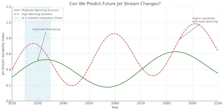
The Role of Satellites and Artificial Intelligence
New satellite systems are helping scientists track the jet stream in near real-time, offering valuable insights into wind speeds, temperatures, and moisture levels high in the atmosphere. Combined with artificial intelligence, this data can improve weather forecasts and help anticipate unusual jet stream behavior earlier than ever before.
AI is especially good at detecting hidden patterns in massive amounts of climate data—something traditional methods might miss. As this technology evolves, it could open the door to more accurate long-range forecasting and better preparation for extreme weather events.
So, can we predict future jet stream changes? Not perfectly. But we’re making progress. The more we understand the forces shaping the jet stream, the better we can prepare for the weather challenges ahead.
Staying informed about these developments isn’t just for scientists—it’s for everyone who depends on accurate forecasts, stable agriculture, reliable travel, and a safer future.
Final Thoughts
The jet stream may be invisible, but its impact is anything but. As it becomes more unstable due to climate change, we’re seeing more intense heatwaves, floods, cold snaps, and storms. These wild weather swings are no longer rare—they’re becoming part of everyday life.
Understanding the jet stream’s role helps us make sense of these shifts. It also highlights why science, technology, and early warning systems are more important than ever. The better we can track and predict these powerful winds, the more prepared we’ll be for what’s ahead.
Weather will always have its surprises, but we don’t have to be caught off guard. Staying informed and aware of how the jet stream shapes our world is a smart step toward resilience in a warming climate.