

Powerful Cloud Bursts Can Trigger Sudden Plummet In Weather
Cloud Bursts Explained: The Fast-Moving Storms That Shift Weather in Minutes
Powerful weather can change fast, and cloud bursts often sit at the center of those sudden turns. These short, intense surges of rain can overwhelm streets, reshape landscapes, and disrupt daily routines before anyone has time to react. As storms grow more unpredictable, understanding how cloud bursts trigger sharp drops in local conditions becomes even more important for staying safe.
Conditions can shift from calm to chaotic in minutes. One moment the air feels thick and still, and the next a dense curtain of water slams down with little warning. This kind of rapid shift catches many people off guard, yet it is becoming more common as warmer air systems hold more moisture. Because these bursts carry so much energy, they can spark flash flooding, damage infrastructure, and unsettle entire communities.
Looking ahead, the frequency and intensity of sudden rainfall events are expected to rise. That means more of us will need to pay attention to how these storms form and why they behave the way they do. Understanding the early signs can help you respond faster and feel more prepared when the sky turns turbulent.
How Cloud Bursts Can Disrupt Local Weather in Minutes
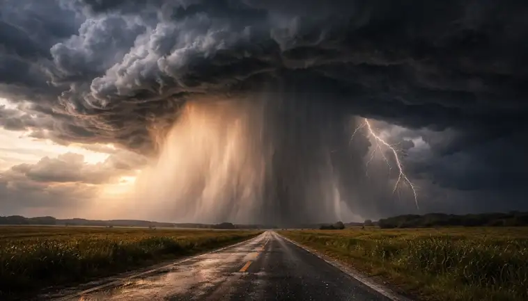
Cloud bursts may sound like something out of a dramatic film. Yet they are very real, and they can reshape your local weather before you even realise what is happening. These sudden, intense downpours often happen with little warning. And because they release so much water so quickly, they can shift the mood of a neighbourhood, a valley, or even an entire town in minutes.
When a cloud burst hits, it is not just another heavy shower. It is a rapid release of energy and moisture. This can push small streams over their banks, flood streets, and cool the air around you almost instantly. One moment the sky feels calm. The next, the world is soaked, loud, and transformed.
Why Timing Matters
Because cloud bursts are so fast, they leave very little room for preparation. Weather systems that normally unfold over hours can compress into a short, intense burst of action. This can change wind patterns, temperature, and visibility almost immediately. In some cases, these quick shifts can disrupt travel, halt events, or even trigger local emergencies.
As our climate warms, the atmosphere holds more moisture. This means cloud bursts may become more common in many regions. Understanding how they form and what they can do helps you stay alert. It also encourages communities to rethink drainage, early warnings, and emergency planning.
So the next time you see dark, swelling clouds on the horizon, take a moment. Conditions can change faster than you think. And with cloud bursts becoming part of our new normal, staying aware is one of the simplest ways to stay safe.
Why Sudden Downpours Are Becoming More Common Worldwide
Sudden, intense downpours used to feel unusual. Now they seem to appear out of nowhere, drenching cities and disrupting daily life. You may have noticed this shift yourself. And you’re not imagining it. Heavy rainfall events are increasing across much of the world, and the pattern is becoming clearer each year.
The reason is simple at its core but alarming in its effect. As the planet warms, the air holds more moisture. When that moisture is released, it falls fast. This means storms can dump more rain in a shorter amount of time. As a result, flooding happens more often, even in places that rarely dealt with it before.
Yet this change is not only about warmer temperatures. Shifts in weather systems also play a role. Jet streams are becoming more erratic. Storms stall more often. When they slow down, they release even more rain over one area. This creates conditions that overwhelm drains, rivers, and streets.
You can think of it as nature hitting the “intensify” button on storms. And it’s happening across continents. From cities in Asia to coastlines in Europe and neighborhoods in the United States, people are noticing the same trend. These downpours are becoming a defining feature of modern weather.
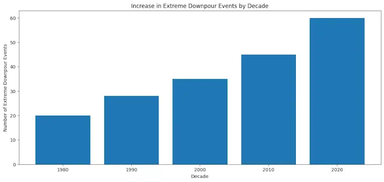
To help you see the pattern more clearly, below is a chart that highlights the rise in extreme rainfall events over the past few decades.
The Hidden Ways Cloud Bursts Set Off Rapid Temperature Drops
Cloud bursts can feel sudden and almost shocking. One moment the air is warm and heavy. The next, cold winds rush in and the temperature dips fast. If you have ever stepped outside during one of these downpours, you know the change can happen in minutes. Let’s walk through why this happens and how it affects your day.
Cloud bursts pull huge amounts of heat out of the air. As rain falls, it cools the atmosphere around it. The air rushed downward by the storm is cooler too. When that cooler air spreads across the ground, temperatures drop quickly. This mix of rain, wind, and shifting air layers creates the sharp chill many of us feel.
Here are a few ways these sudden cloud bursts trigger cooling:
- Heavy rain evaporates as it falls, which pulls heat from the air.
- Cold downdrafts push cooler air toward the ground.
- Thick storm clouds block sunlight, reducing surface warming.
- Rapid pressure changes guide cooler winds into the area.
As odd as it sounds, these quick shifts are part of a larger pattern. Weather is becoming more unpredictable, and cloud bursts are showing up more often in many regions. So paying attention to these signs can help you adjust faster. And with storms growing stronger, it’s worth watching how these rapid temperature drops fit into the bigger climate story.
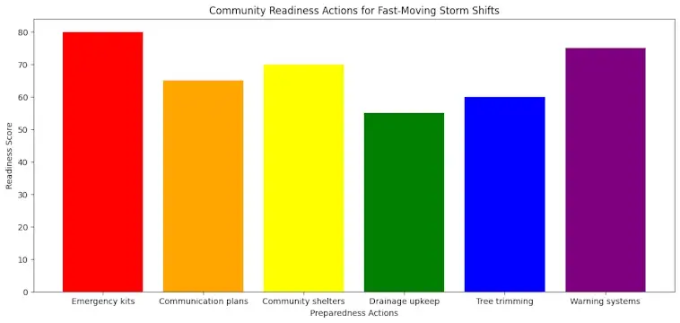
What Communities Can Do To Prepare for Fast-Moving Storm Shifts
Fast-moving storms can catch anyone off guard. Yet communities that plan ahead tend to recover faster and face fewer losses. The good news is that preparation does not have to feel overwhelming. When people work together, small actions add up. And as these storms become more unpredictable, taking clear, practical steps now can make a real difference later.
Communities can start by strengthening the basics. Keeping emergency kits stocked helps households stay safe when services are disrupted. Setting up simple communication plans ensures people know where to go for updates. Local shelters also play a key role, offering a safe place when evacuation is needed. In addition, regular maintenance—like clearing drains and trimming weak trees—reduces avoidable damage. Finally, investing in early-warning tools allows neighborhoods to react faster when weather conditions shift without notice.
Even a few coordinated steps create momentum. And once a community begins this work, it becomes easier to build a culture of readiness that protects everyone.
Where Extreme Rainfall Is Most Likely To Strike Next
Storms are growing stronger. And when they hit, they hit fast. Many communities are learning this the hard way. Yet the bigger challenge is that these events are no longer tied to a predictable rainy season. They can now arrive almost anywhere, at almost any time.
Weather researchers are watching several hot spots around the world. These include regions with warming coastlines, growing urban heat zones, and landscapes already saturated from recent storms. As sea temperatures climb, storms gain more energy. They then unload that energy in short but intense bursts of rain. That is why we are seeing what used to be “once in a century” downpours happening far more often.
Urban areas face the highest risk. Cities trap heat. They also shed water quickly, which means extreme rainfall has nowhere to go. That leads to sudden flooding. Meanwhile, inland regions with shrinking soil moisture and shifting jet streams are seeing surprise deluges, even in places not known for heavy storms.
Why Cloud Bursts Are Becoming More Common
Cloud bursts are sudden, powerful, and deeply disruptive. They often form when warm, humid air rises fast and collides with cooler air. The result is a rapid release of rain over a very small area. With temperatures rising, the atmosphere can hold more moisture. That makes these events more explosive than ever.
If you want a deeper dive into how global temperatures influence heavy rainfall, the World Meteorological Organization offers a clear overview.
Across the board, extreme rainfall is no longer a distant concern. It is a growing part of daily weather patterns. And as conditions continue to shift, being informed is one of the best tools we have to stay safe.
Conclusion: Why Cloud Bursts Deserve Our Attention
Cloud bursts may seem rare, yet their impact can be sudden and severe. As we look ahead, it is clear that these intense downpours will shape how communities prepare for fast-changing weather. By understanding how cloud bursts form and why they trigger such sharp drops in local conditions, we can make smarter choices.
Moving forward, paying attention to early warning signs and improving local resilience will matter even more. And while we cannot control the sky, we can stay informed, stay ready, and stay safe. When we do, cloud bursts become less of a shock and more of a challenge we know how to meet.